
Photograph by Brooks Walker
Life Atop a Cauldron
From the April 2011 issue of National Geographic Traveler
ByJonathan Tourtellot
April 02, 2012
20 min read
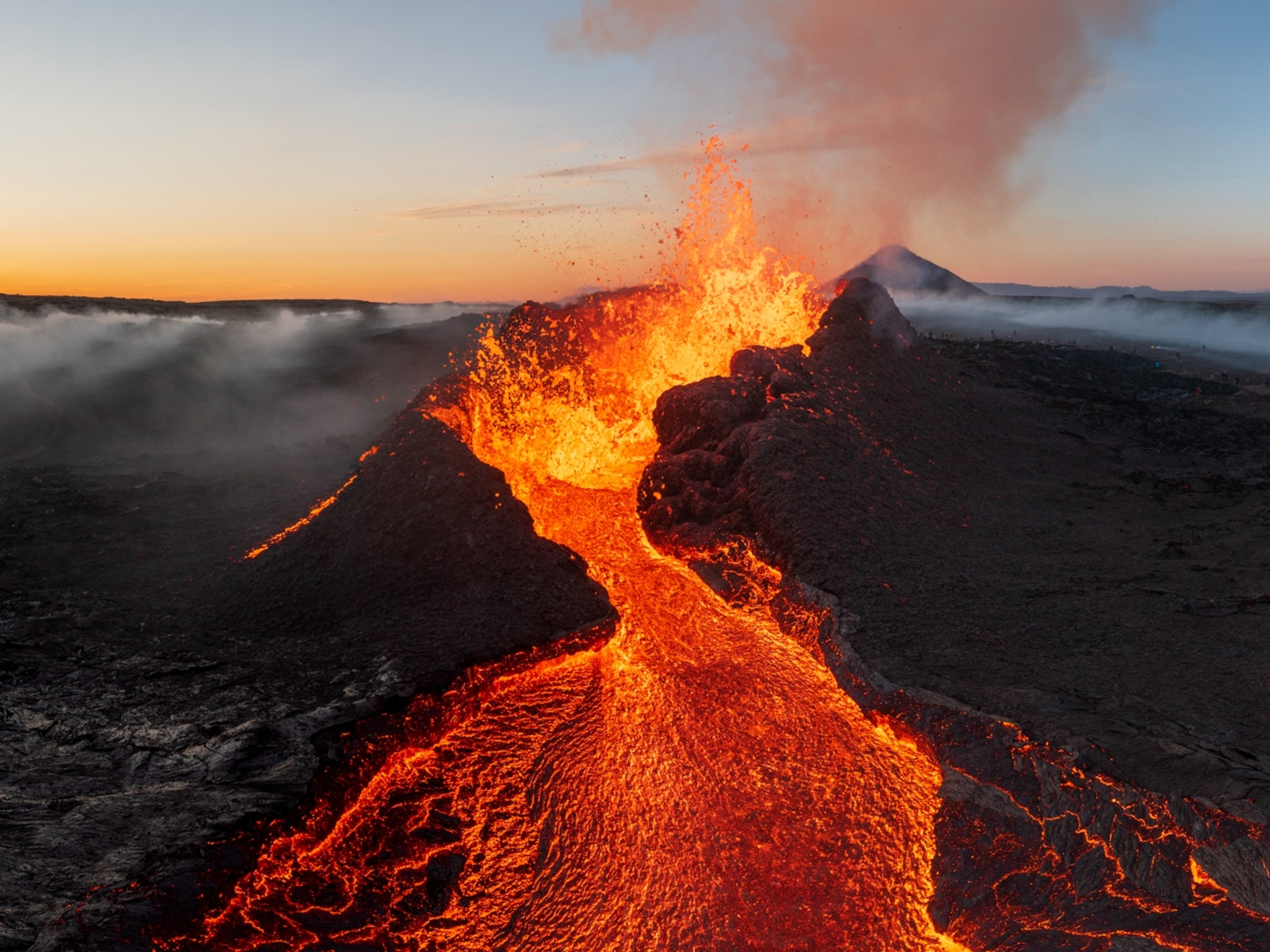
“I can take you up over the volcano” exclaims the enthusiastic pilot. “This is a unique opportunity in human history! We will fly down into the new ice canyon like a slalom.” He weaves his hands snakelike, adding helpfully: “Down is better. Flying up the canyon, we might crash.” He spiels on, a nonstop lava flow of commentary on volcanic wonders, environmental outrages, government foolishness—I lose track. The volcano in question is Eyjafjallajökull, whose ashy eruptions last year famously shut down European air traffic for days, creating the worst aviation stoppage since World War II (and also a pronunciation stoppage among American newscasters; most resorted to “that vol-CANE-oh in ICE-land”).
The pilot in question is Iceland’s irrepressible Ómar Ragnarsson, 70, renowned radio entertainer, filmmaker, news anchor, journalist, comedian, politician, and environmentalist. This summer, he interrupts blogging about threats to his treasured Icelandic countryside to show people close-up views of Eyjafjallajökull (“EHya–fyettla–yuhkuttle” comes close) from the cockpit of his 35-year-old Cessna 172.
The prospect gives me pause. Putting my life in the hands of an excitable, geriatric pilot who wants to air-slalom down a restless volcano in a rattletrap plane is, well, not quite in our plan.
But it’s close. My wife, Sally, and I have made volcanoes the theme of this visit to Iceland (our third together and my sixth). We always relish this island nation’s mix of a literate, unusual culture of 309,000 overachievers and a wild, weird landscape. During humid Virginia summers, when the crisp Icelandic air beckons, we grab any excuse to go, including an eruption.
Iceland sits atop the Mid-Atlantic Ridge, the belt of mountains and rift valleys where episodic eruptions widen the floor of the Atlantic Ocean. Hoping to learn what it’s like to live on such tumultuous real estate, we’ll follow the country’s main volcanically active zone from the Westman Islands off the south coast, across the Arctic desert interior, to the town of Húsavík on the northeast coast. Our only worry: Will the recent eruption have attracted crowds of tourists?
The Black Glacier
On our arrival in Iceland I posed a different question to our old friends Ingibjörg (Inga) Elíasdóttir and Árni G. Sigurdsson. It concerned Eyjafjallajökull’s more active volcanic neighbor to the east.
“Will Katla erupt?”
That wasn’t just idle curiosity. Katla is the biggie. When it blows, it flash-melts part of its ice cap, sending an Amazon-size flood—the infamous jökulhlaup, or glacier burst—across the coastal plain to the sea. That would wipe out everything in its path, including part of the national Ring Road around Iceland.
Inga shrugged. “All my life Katla has been about to erupt.” We sat at the dining table in Inga and Árni’s weekend house in Grímsnes, about an hour east of Reykjavík. Plate-glass windows framed a table mountain, where, in 2008, they saw an earthquake trigger a landslide.
Katla goes off every 70 years, give or take 50. The three times in history that Eyjafjallajökull erupted previously, Katla followed within a year or two. Maybe we should be more fearful ourselves.
We had met Inga, a public health inspector, and Árni, a now retired airline captain, 15 years ago on holiday in the Caribbean. We have visited back and forth with the married couple ever since. For them, living with at least one eruption every few years is part of life. “Pilots practice for it,” Árni said. “Often it’s best to fly under the ash, because the volcano sends it so high.”
Everybody has stories about the 2010 eruptions. On Eyjafjallajökull, east of the main summit crater, an eruption opened vents, building two new cones. Inga showed us photos of it from her post-eruption hike last May. “That’s a new mountain,” she said with pride: In Iceland, we make mountains. On the volcano’s northern slope, lava flowing beneath a shallow glacier collapsed the overlying ice, creating the ice canyon that Ómar wants to fly me through.
We drove east toward Eyjafjallajökull in Árni’s vibrantly red 4WD pickup truck. The mountain’s ice cap crowned the morning mists—in black, not white. “It looks like a mistake in the sky,” Sally noted. Two to three feet of sooty ash blanketed the volcano’s glacier.
We stopped at a shopping center and ran into Thorey, the wife of a pilot friend of Árni’s. Ash and floods from the eruption, she tolds us, cut off the couple’s return to Reykjavík during a weekend outing to the south coast. To get home, they had to drive for two days counterclockwise all the way around Iceland. She pointed to the family dog in her car, named for the volcano. “She is Eyjafjallaskotthildur.”
“You actually call her that?” I asked.
“See her tail? It’s white at the tip and black farther up—like the white glacier covered in ash,” Thorey said. She gazes fondly at the dog. “We call her Skotta for short.”
Whew.
Now, near Hvolsvöllur, Árni takes us to meet Ómar, who’s holding court in the lobby of a hotel in his customary jacket and tie, laptop in mid-blog. I give in to his persuasion, and we adjourn to a nearby airstrip where his weathered Cessna awaits. Sally gives me a disconcertingly hard “come back alive” kiss. Ómar and I strap in and take off.
In minutes we’re flying over the braided river flowing from the valley behind the volcano, the terrain below a mix of summer green and black patches of residual ash. Soon we top Eyjafjallajökull’s capping glacier, a weirdly fractured, blackened crust. It looks like a fallen soufflé burned on top.
“There’s the canyon,” Ómar yells over the engine. Black and white turrets of ice and ash rise on each side of a winding layer of steamy fog. He dives low over the mist—plenty thrilling—but isn’t satisfied. “I think I can get under it,” Ómar shouts. Oh, great.
He banks and climbs back to the summit, then turns sharply. We dive under the fog layer, slaloming down the canyon, ice walls not far from each wing tip. He slows to a near stall, flying the plane with one hand and shooting pictures with the other. He’s either a great aviator or a terrible one. It’s a helluva ride.
The canyon is “something humans may never see again, especially if global warming melts the glaciers,” Ómar tells everyone after we land (while I’m still exhaling). Clearly he considers Iceland’s explosive geology remarkable. Various faults, rift valleys, grabens, and fissures form as tectonic plates carry Europe and North America apart. The two main rift zones that cleave southern Iceland leak lava, spew hot springs, and sprout new volcanoes. The western zone rises from the sea, becoming the Reykjanes peninsula, then turns inland from Reykjavík, counting among its famous features Thingvellir, the valley where in Viking times the Icelandic parliament met outdoors, literally on the edge of a fissure; and Geysir, the geyser field that gave us the word.
Incendiary Islands
But we go next to the southern branch of the rift zone, which has made new land more recently—offshore. We’re following a plastic-lined trough dug through packed ash (tephra) on Heimaey, the main island in the Westman archipelago off Iceland’s south coast. Rounding a bend we see something white and angular peeking out. It’s the top corner of a two-story house.
Excavation here at the “Pompeii of the North” has begun. A sign stuck in the cinders names the family that lived here before January 23, 1973, when a fissure opened in the fishing port town of Vestmannaeyjar. Luckily, the fleet was in harbor and, as the fountain of fire grew, evacuated the island’s population of 5,300 within hours. Árni tells us how his islander friend Johann Johannsson recalls the eruption. “He was 12 when it happened. The day of the evacuation, he remembers that his mother made them finish breakfast before they could leave for the boats.” Ah, Icelanders! The eruption can wait while you finish your oatmeal.
The eruption created a mountain and bulldozed some 300 homes. Battalions of boats tried to halt the advancing lava with hoses, and the effort may have worked. The flow stopped short of sealing the port, actually improving the harbor, though many houses collapsed under the weight of falling ash.
When I first visited here in summer 1973, just after the eruption ended, the ash was still hot. The rugged island was surreal then, a volcanic haze defying a fierce wind, black ash still covering slopes. Residents hadn’t yet returned, but workers and international volunteers were cleaning everything. Notices at the Reykjavík airport warned Heimaey visitors that if walking on the black lava to make sure their soles didn’t catch fire. At the time, a local guide took me to a house only two-thirds buried in ash. We clambered down into an upstairs window, through the bedroom, and into a narrow hall. “This door leads downstairs,” he said, and opened it. A hellish blast of moist air heated by the nearby lava burst out. The ceiling rained condensation. He slammed the door shut.
Now, 37 years later, we grab lunch in the Café Kro, where weekend tourists from Reykjavík relive the eruption via a grainy documentary film—old history. To me, yesterday.
By 1974, islanders were running pipes through the lava and using it to heat the recovering town. Nowadays, geothermal heating meets the heat and hot water needs of 92 percent of the nation’s buildings. A first-time visitor emerging from a Reykjavík washroom told me, accurately: “One of those taps is connected to a glacier and the other to the depths of hell.” Reykjavík even heats some streets and sidewalks. In 1980, the outflow from a new geothermal power plant 29 miles away on the Reykjanes peninsula began drawing bathers with its mineralized, cobalt-colored water. It evolved into the famed Blue Lagoon spa, a top tourist attraction.
But geothermal power, which I’ve long thought the most benign of renewable energies, has become contentious. After the 2008 economic collapse, during which the value of the kronur fell by as much as 76 percent against the dollar, national leaders have been willing—too willing, say some—to sell Iceland’s two abundant resources, namely, fish and energy. A third resource is the scenery that attracts us tourists. And therein lie the controversies.
On the way back to our friends’ cottage, I’m reading in the capital’s sassy English-language biweekly, the Reykjavík Grapevine, an open-letter debate over geothermal plants. It’s between singing star Björk and Ross Beaty, CEO of a Canadian geothermal company named, yes, Magma. Magma Energy Corp. has won a government contract that, says Beaty, will bring in needed foreign revenue. Björk counters that more geothermal plants will deface the landscape, overtap the geothermal fields, and spew too much volcanic gas into the air. I recall Ómar railing about a geothermal plant proposed for a pristine part of the rift zone up north. That’s where we’re headed next.
Between Glaciers
The paved road gradually climbs out of the lush southern farm country. From the pickup’s four-person cab, we watch the vegetation get thinner, farms sparser, the land drier, the horizons farther, and the sky closer. In 40 minutes we’ve gone from cozy countryside to the Highlands, an uninhabited, big-sky wilderness. The pavement ends as we proceed across Iceland’s desert interior on the F26, or Sprengisandur track, paralleling the rift zone. The dusty track is just wide enough for two vehicles to pass and open only in summer.
You can make the 124-mile crossing in just a day, weather and water levels permitting. Nevertheless, Árni has provisioned the truck to last a nuclear winter. We bump along at a respectable pace through open volcanic desert. Within a couple of hours the Hofsjökull glacier is filling the skyline to the west. A few mountain peaks appear above the ice. “I’ve climbed that one, and that one last year,” notes Inga, grandma mountaineer. “The glacier is melting back,” she adds. We are crossing a corner of Europe’s largest national park, Vatnajökull. Its namesake glacier, also Europe’s largest, sprawls far to the east. We can see the edge of it on our right. Beneath it lies the heart of the cauldron.
Iceland is not only a seafloor spreading zone, it may even be causing the spreading. Under Vatnajökull, an upwelling plume of magma—a hot spot—from the Earth’s mantle feeds the volcano Grímsvötn, which erupted in 1996, 1998, and 2004. The ’04 outburst melted through some 500 feet of ice in about an hour and sent up a blast of ash that reached Finland. Some geologists say the hot spot may be breaking apart the Earth’s crust like a spike splitting a weak plank. If there is a point where Europe and North America are truly wedged apart, it’s here.
The summer sun is still high at 6 p.m., when we finally descend into the Krókdalur valley. We admire a series of glacier-fed waterfalls. Pavement returns. By nightfall we have reached our farm-stay hostel near the charming north coast port of Húsavík, a whale-watching center. Local interests are at odds with Icelandic traditionalists elsewhere who insist on continuing the country’s controversial whaling industry. The Húsavík economy now depends more on people who prefer seeing whales in the water, not on their dinner plates.
Power Plant Perils
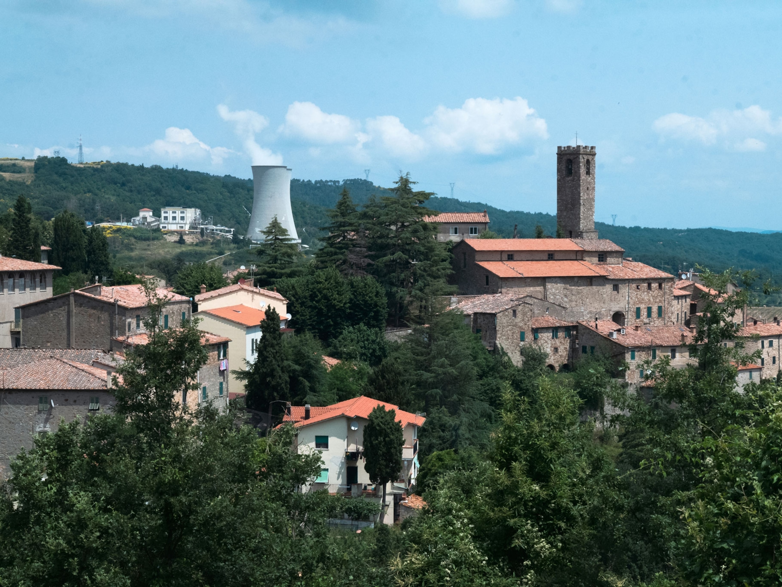
The best known attraction up here in the north end of the rift zone is Mývatn, a relatively shallow lake famed for its many waterbird species (including more than 25 species of ducks) and assortment of geological oddities: fissures with hot spring–fed pools you can swim in; the ash crater of Hverfjall, formed in a single eruption; Dimmuborgir, the Dark Castles, a tangled maze of volcanic rock; and “pseudocraters,” formed when trapped water popped through overlying molten lava as steam. The lake also has a new geothermal spa, Mývatn Nature Baths, a mini Blue Lagoon.
But I want to explore the area just to the north, where the Krafla volcano threatened the daring geothermal power plant built on its flanks in the 1970s. The plant was one of the first to tap a “high temperature field,” making the project a learning experience. One well blew up, leaving a crater. Magma shot out of another borehole. Fissure eruptions continued right up the valley. These “Krafla Fires” spewed intermittently for years, as the valley grew three feet wider. On a 1981 visit I explored a new layer of coal black lava (remembering to check my shoes) and saw how only an intervening rise of land kept it from flooding the power plant.
Almost three decades later the lava looks... the same! Just as jarringly black. Now, though, we join tourists on a boardwalk that allows everyone to stroll around, exploring the flow and sniffing the sulfur from steam vents. The flow sits in the grassy valley like a spill of lumpy fresh tar, “as if someone started to pave the landscape,” remarks Sally, “and just walked away.” It may take decades, even centuries, for moss, then grass, to colonize it.
The power plant works pretty well now and is interesting to see. A jeep track goes farther north into a still pristine area called Gjástykki, but it’s chained, awaiting the proposed geothermal plant that Ómar fumed about. Gjástykki is a band of terrain shredded with parallel fissures. It’s one of the last undeveloped places on land where you can see how the Earth forms new crust.
“But you can’t go there until it is harnessed with wells and pipes and power lines,” Ómar complained. “This is nonsense!”
The Ómar-Björk camp says enough is enough. “You could make more money with tourism,” argues one geologist. Should Gjástykki be tapped for industry or preserved as a World Heritage site? So goes the debate.
Hellfire in Hexagons
We don’t know it yet, but we’re standing inside a volcano. A 130-foot-high mass of strangely hexagonal stone, twisted at a scramble of odd angles, towers into the sky above us.
“These are the Echo Cliffs,” says Hjörleifur Einarsson, who manages this northern section of Vatnajökull National Park, northeast of Krafla. “We are looking at basalt columns of every form and size possible.” He explains that some 8,000 or 9,000 years ago the huge fissure around us erupted in a five-mile-long lava flow, filling this gorge to a point far above our heads. Later, catastrophic floods eroded parts of the flow away. “So now you get to see what a volcano core looks like from the inside.”
This gorge is a world wonder camouflaged by syllables. It’s tough to tell American friends: “Be sure to see Jökulsárgljúfur in Vatnajökulsthjódgardur!” (In English, that would be “See Glacier River Canyon in Water-Glacier National Park.”)
Neither language does it justice. Jökulsárgljúfur gorge is the Louvre of lava, probably the world’s most imposing display of basalt columns. Often the columns are vertical, and Europe’s mightiest waterfall, Dettifoss, upstream, flows over some of them. Below the falls, the cathedral becomes more of a colossal fun house, a tumbled tumult of basalt—columns at diagonals, sideways, and in honeycomb cross sections; archways of columns, radial sprays of columns, looming towers of columns like the one above us.
Jökulsárgljúfur’s fine new visitor center, created in 2007, stands at the threshold of the bizarre horseshoe-shaped canyon called Ásbyrgi. The space resembles a giant waterfall gone dry, apparently created by glacial floods 3,000 to 11,000 years ago.
Along the road back to Húsavík, we stop where several old fissures stretch away to the south, a few farmhouses sited fearlessly among them. Beyond lies the very far end of the closed-off Gjástykki area. North of the highway is Skjálftavatn—Earthquake Lake—formed after a series of quakes. Not far beyond, the rift zone sinks back under the sea, snaking onward under the Arctic Ocean. The surrounding summer green pastures make a deceptive coda to our trans-island trek over this restless terrain. So bucolic, so peaceful—until the next time the land jerks wider.
Next day Árni and Inga take us back south across the highlands on the more westerly F35 track. It crosses cinder-strewn parts of the western rift where Magma Energy seeks more geothermal fields. Outside of Reykjavík we share a farewell meal in Inga’s childhood town, Hafnarfjördur, nicknamed “the Town in the Lava.” Charming, brightly painted houses contrast with surrounding battered, black, and barren lava flows, thousands of years old.
We take the road back to Keflavík, the international airport atop the Mid-Atlantic Ridge. This is the landscape arriving tourists first see. Contrary to our worries, they haven’t flocked to Iceland to see the volcanoes. In fact, fears of Katla erupting have apparently kept them away, leaving more of Iceland’s sites to ourselves.
Iceland is one of the only places, as Ómar says, where you can see the Earth under construction. It’s a messy, thrilling, unforgettable spectacle. Eruptions are dangerous and deserve respect, but they are also a travel opportunity.
As our Icelandic friends, old and new, have shown us, you can live with lava. Once we’re aboard our return flight to North America, I reflect that I still haven’t seen an eruption in action. Maybe I’ll keep a bag packed.
Behind us, the volcanoes doze, their bowels astir.
Geotourism Editor Jonathan Tourtellot is a National Geographic Fellow. Photographer Brooks Walker, based in Reykjavík, shot “Bavaria on Tap” for our September 2007 issue.


You May Also Like


Go Further
Animals
- This ‘saber-toothed’ salmon wasn’t quite what we thoughtThis ‘saber-toothed’ salmon wasn’t quite what we thought
- Why this rhino-zebra friendship makes perfect senseWhy this rhino-zebra friendship makes perfect sense
- When did bioluminescence evolve? It’s older than we thought.When did bioluminescence evolve? It’s older than we thought.
- Soy, skim … spider. Are any of these technically milk?Soy, skim … spider. Are any of these technically milk?
- This pristine piece of the Amazon shows nature’s resilienceThis pristine piece of the Amazon shows nature’s resilience
Environment
- This pristine piece of the Amazon shows nature’s resilienceThis pristine piece of the Amazon shows nature’s resilience
- Listen to 30 years of climate change transformed into haunting musicListen to 30 years of climate change transformed into haunting music
- This ancient society tried to stop El Niño—with child sacrificeThis ancient society tried to stop El Niño—with child sacrifice
- U.S. plans to clean its drinking water. What does that mean?U.S. plans to clean its drinking water. What does that mean?
History & Culture
- Séances at the White House? Why these first ladies turned to the occultSéances at the White House? Why these first ladies turned to the occult
- Gambling is everywhere now. When is that a problem?Gambling is everywhere now. When is that a problem?
- Beauty is pain—at least it was in 17th-century SpainBeauty is pain—at least it was in 17th-century Spain
- The real spies who inspired ‘The Ministry of Ungentlemanly Warfare’The real spies who inspired ‘The Ministry of Ungentlemanly Warfare’
- Heard of Zoroastrianism? The religion still has fervent followersHeard of Zoroastrianism? The religion still has fervent followers
Science
- Here's how astronomers found one of the rarest phenomenons in spaceHere's how astronomers found one of the rarest phenomenons in space
- Not an extrovert or introvert? There’s a word for that.Not an extrovert or introvert? There’s a word for that.
- NASA has a plan to clean up space junk—but is going green enough?NASA has a plan to clean up space junk—but is going green enough?
- Soy, skim … spider. Are any of these technically milk?Soy, skim … spider. Are any of these technically milk?
- Can aspirin help protect against colorectal cancers?Can aspirin help protect against colorectal cancers?
Travel
- What it's like to hike the Camino del Mayab in MexicoWhat it's like to hike the Camino del Mayab in Mexico
- Follow in the footsteps of Robin Hood in Sherwood ForestFollow in the footsteps of Robin Hood in Sherwood Forest
- This chef is taking Indian cuisine in a bold new directionThis chef is taking Indian cuisine in a bold new direction
- On the path of Latin America's greatest wildlife migrationOn the path of Latin America's greatest wildlife migration
- Everything you need to know about Everglades National ParkEverything you need to know about Everglades National Park
